Visual Materials
A Map of Part of West Florida, from Pensacola to the Mouth of the Iberville River, with a view to show the proper Spot for a Settlement on the Mississippi

You might also be interested in

A new chart of the seas surrounding the island of Cuba : with the soundings, currents, ships courses &c and a map of the island itself lately made by an officer in the Navy
Visual Materials
Jolly attributes the engraving to Kitchin. Sub-map: Plan of the Harbour and Town of Havana. MS note: 384 (on backing). Prime meridian: London. Relief: pictorial. Graphic Scale: Miles. Projection: Cylindrical. Watermark: Seal. Printing Process: Copper engraving. References: Jolly British Periodicals LOND-217.
105:384 S
Image not available
A map of the country round Philadelphia : including part of New Jersey New York Staten Island & Long Island
Visual Materials
Kashnor dates as ca. 1760. Jolly identifies as from Gentleman's Magazine, of Sept. 1776 [as does printing transfer on verso]. MS note: 729 (on backing). Prime meridian: London. Relief: pictorial. Graphic Scale: Miles. Projection: Cylindrical. Printing Process: Copper engraving. References: Jolly, Brit. Periodicals Gent-247. Verso Text: Text transfer.
105:729 S

New & Accurate Map of the Seat of the late War in the West Indies with a plan of the City and Harbour of Havannah. 1763
Visual Materials
Submap: Havana Harbor. MS note: 757 (on backing). Prime meridian: Ferro. Relief: pictorial. Projection: Cylindrical. Printing Process: Copper engraving. Other Features: Sub-maps. Verso Text: MS note: 757 (on backing).
093:757 S

A new map of the island of Jamaica : divided into its parishes including the south end of Cuba and the west end of Hispaniola with the trade winds &c / drawn from the best surveys by Thos. Kitchin Geogr
Visual Materials
Two submaps. Kashnor dates as ca. 1780. Jolly notes London Magazine publication date as July 1763. Duplicate of 105:461. Submaps: Chart of the Windward Passage; Plan of Port Royal Harbour. MS note: 461 (on backing). Prime meridian: London. Relief: pictorial. Graphic Scale: Miles. Projection: Cylindrical. Printing Process: Copper engraving. Other Features: Sub-maps. References: Jolly Brit. Period. LOND-228.
105:460 M

New Map of the Island of Jamaica Divided into its Parishes Including the South End of Cuba and the West End of Hispaniola with the Trade Winds &c. Drawn from the best Surveys by Thos. Kitchin Geogr
Visual Materials
Two submaps. Kashnor dates as ca. 1780. Jolly notes London Magazine publication date as July 1763. Duplicate of 105:460. Submaps: Chart of the Windward Passage; Plan of Port Royal Harbour. MS note: 460 (on backing). Prime meridian: London. Relief: pictorial. Graphic Scale: Miles. Projection: Cylindrical. Printing Process: Copper engraving. Other Features: Sub-maps. References: Jolly Brit. Period. LOND-228.
105:461 M
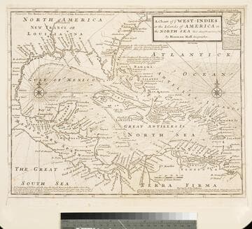
Chart of the West Indies or the Islands of America in the North Sea &c. Being the Present Seat of War. by Herman Moll Geographer
Visual Materials
Kashnor notes, "Shows the mainland around the Gulf of Mexico, with Louisiana, Florida, Georgia, and Carolina." Kashnor dates as ca. 1719. Submap: Vera Cruz harbor. Sailing instructions for galleons. MS note: 321 (on backing). Prime meridian: London. Relief: no. Projection: Cylindrical. Watermark: Two devices. Printing Process: Copper engraving. Other Features: Sub-maps.
105:321 S