Visual Materials
Seat of War in America
You might also be interested in
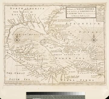
Chart of the West Indies or the Islands of America in the North Sea &c. Being the Present Seat of War. by Herman Moll Geographer
Visual Materials
Kashnor notes, "Shows the mainland around the Gulf of Mexico, with Louisiana, Florida, Georgia, and Carolina." Kashnor dates as ca. 1719. Submap: Vera Cruz harbor. Sailing instructions for galleons. MS note: 321 (on backing). Prime meridian: London. Relief: no. Projection: Cylindrical. Watermark: Two devices. Printing Process: Copper engraving. Other Features: Sub-maps.
105:321 S
Image not available
Map of that part of America which was the Principal Seat of War. in 1756
Visual Materials
Kashnor notes, "Nova Scotia to Massachusetts, and westward to Lake Ontario and the St. Lawrence." Kashnor dates as ca. 1760. RLIN record suggests printing date of 1757. MS note: 661 (on backing). Prime meridian: London. Relief: pictorial. Graphic Scale: Miles, leagues. Projection: Pseudocylindrical. Printing Process: Copper engraving.
105:661 S

A Plan of the Harbour of St. Augustin in the Province of Georgia
Visual Materials
Kashnor notes, "A very rare chart issued for the commanders of ships of war during the Revolution. It shows a very good plan of the city of St. Augustin, with Fort St. Mark and the fortifications. Coloured impressions are very rare." Kashnor dates ca. 1780. Relief: hachures. Graphic Scale: Miles, feet. Projection: Plane. Watermark: Crowned fleur-di-lis J. Bates. Printing Process: Copper engraving. Verso Text: MS note: 991.
105:991 M

Principall Islands in America Belonging to the English Empire, viz Jamaica, Barbados, Antegoa, St. Christophers, & Bermudos
Visual Materials
Kashnor notes, "Contains one of the rarest maps of Bermuda." Kashnor dates as ca. 1685. Eight maps on one sheet. See 105:190 for later revised version. Eight maps on one sheet.. Relief: pictorial. Projection: Plane. Watermark: H. Printing Process: Copper engraving. Other Features: Sub-maps. Verso Text: MS note: 192.
105:192 M

A new and accurate map of the present seat of war in North America, from a late survey
Visual Materials
Kashnor notes, "A scarce map, issued during the early part of the Revolution." Kashnor dates c.1776. RLIN record places publication in London and appearance in Universal Magazine. MS note: 107 (on backing). Prime meridian: Ferro. Relief: pictorial. Graphic Scale: Miles. Projection: Cylindrical. Watermark: Two seals. Printing Process: Copper engraving.
105:107 S

Stanford's map of the seat of the war in America
Rare Books
Kirkpatrick Catalogue entry: "2480 l Stanford, Edward, publisher. Stanford's Map of the Seat of the War in America. London, Edward Stanford, 1861. 1 sheet. [see p.]."MS notes at top of sheet give a date and identify one former owner of the map as a Lieutenant Colonel in the Rifle Brigade, though it does not say which one. Publishers' advertisement pasted to verso. MS notes: N.W. Fyns(?) Lieut. Coll. Rifle Brigade. Lent this map Aug. 31st 1862.. Prime meridian: GM. Relief: hachures. Graphic Scale: Miles. Projection: Polyconic. Printing Process: Lithography. Verso Text: MS notes: N. America Civil War 1862 RB 11489,n p maps Stanford 1861. Stamps: Kensington Public Libraries..
623654