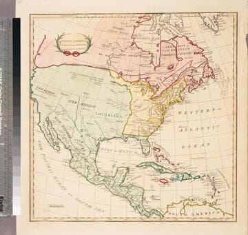
Visual Materials
Accurate map of the United States of America, with Part of the Surrounding Provinces agreeable to the Treaty of Peace of 1783. by Jno. Cary
You might also be interested in

Accurate Map of the United States of America, with part of the Surrounding Provinces agreeable to the Treaty of Peace of 1783, by Jno. Cary
Rare Books
Kashnor notes, "A very rare map, one of the earliest to be issued after the Treaty of Paris." Articles I-III of the treaty (lower right). Prime meridian: London. Relief: pictorial. Projection: Pseudocylindrical. Printing Process: Copper engraving. Verso Text: MS notes: 130459 Lewis Cage Jnr. C41.
130459
Image not available
North America and the West Indies: a New Map, wherein the British Empire and its limits, according to the difinitive(sic) Treaty of Peace in 1763, are accurately described, and the Dominions possessed by the Spaniards, the French and other European States; the whole compiled from the New Surveys and Authentic Memoirs that have hitherto appeared
Visual Materials
Kashnor notes, "Shows a good map of the Illinois and Ohio country. locating Chicago. The southern boundary of the Hudson's Bay Company territories is along latitude 49, running beyond the Lake of the Woods. In the map are also located the various H. B. Co. forts and factories." Kashnor dates as ca. 1763. Submaps and treaty articles. See 105:669 for another copy. RLIN record suggests 1764 date. Cartouche with Natives. Submaps: Particular Map of Baffin and Hudson's Bay; Map of the Country between Montreal, Albany and Oswego. . Prime meridian: London, Ferro. Relief: pictorial. Graphic Scale: Miles, Leagues. Projection: Pseudocylindrical. Printing Process: Copper engraving. Other Features: CartoucheSub-mapsFigures . Verso Text: MS notes: 532 Map c.1783.
093:532 M
North America in its present Divisions, agreeable to the Peace
Visual Materials
Kashnor notes, "Takes in east and west coasts. Shows the North-Eastern boundary between Maine and Nova Scotia before New Brunswick became a province, the line west follows latitude 49 from the Lake of the Woods, and then bends south to the supposed mouth of the River of the West at latitude 44. Spain is possessed of all the territory from the Mississippi to the Pacific." MS note:145. Prime meridian: London, Ferro. Relief: no. Graphic Scale: Miles. Projection: Pseudocylindrical. Printing Process: Copper engraving.
093:145 M
Image not available
North America from the French of Mr. d'Anville Improved with the English Surveys made since the Peace
Visual Materials
Kashnor notes, "Locates Chicago and gives a good map of the Illinois country and the country around the headwaters of the Mississippi, and the old forts and towns of the Ohio country." See 093:534M for an earlier version by Jefferys. RLIN record adds appeared in information. Prime meridian: London, Ferro. Relief: pictorial. Graphic Scale: Miles, leagues. Projection: Pseudocylindrical. Watermark: Crowned fleur-di-lis over GR. Printing Process: Copper engraving. References: McCorkle 755.2 (1775 state). Verso Text: MS note: 533.
093:533 M

New and Correct Map of North America with the Places of the Principal Engagements during the Present War, are accurately inserted. And the Boundaries as Settled by Treaty in 1783 Clearly Marked
Visual Materials
Kashnor notes, " A scarce map issued immediately after the peace, showing the boundaries, that in the west reach from Lake of the Woods to the Mississippi, and passing down that river. The Maine boundary is practically that which was claimed by the United States up to 1839." Canada is labeled "British America by Treaty" and US territory "Rebel Colonies, now the United States of America." MS note: 142 (on backing). Prime meridian: London. Relief: pictorial. Projection: Mercator. Watermark: Crowned seal seal. Printing Process: Copper engraving.
093:142
Image not available
New and Accurate Map of Louisiana, with Part of Florida and Canada, and the Adjacent Countries, Drawn from Surveys, assisted by the most approved English & French Maps & Charts. The whole being regulated by Astronl. Observations, by Eman. Bowen
Visual Materials
Kashnor notes, "This shows the boundaires of Louisiana according to the French claims which led to war. It is a good map of the Illinois country, locates Chicago, also of New Mexico, with the location of Santa Fe, Taos, and other towns." Kashnor dates ca. 1745, RLIN record suggests 1745. Cartouche: with Indian.. Prime meridian: London. Relief: pictorial. Graphic Scale: Leagues. Projection: Pseudocylindrical. Watermark: Fluer-di-lis V(?) A G. Printing Process: Copper engraving. Other Features: Cartouche. References: Wheat cv.1, no.122.
093:433 M